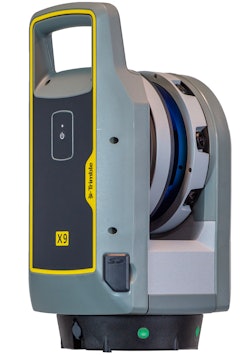

Trimble has announced the launch of the X9 3D laser scanning system, a new reality capture solution for surveying, construction and engineering professionals. The X9 is built on Trimble's laser scanning technologies, engineered for performance in various environments using Trimble X-Drive technology for automatic instrument calibration, survey-grade self-leveling and laser pointer for georeferencing.
A new center unit design supports signal transmission for scan quality. With reality capture capabilities, the X9 broadens potential applications for customers in surveying, building construction, oil and gas, rail, forensics, monitoring, tunneling, mining and others.
The X9 features auto-calibration which eliminates the need for annual calibration. In addition, the X9's self-leveling capability has a wide compensation range.
Trimble X9 data can be delivered directly from Trimble Perspective or FieldLink software to Trimble's office software, including Trimble Realworks 3D scanning software, Trimble Business Center office software, SketchUp and Tekla or exported to produce application-specific deliverables.
"Our customers buy Trimble because they want reliability and performance," said Jason Hayes, market manager, reality capture solutions, Trimble Geospatial. "The Trimble X9 is simple to use, provides unsurpassed reliability, and excels at creating high-quality digital representations of the world for applications ranging from fast-paced building documentation to challenging outdoor surveys."


